Bill McKellar in conversation with Kate McMahon
I thought that for this ‘Do you Know the Difference’, I would write about something I didn’t understand – but do read on. I was able to get expert help, from Kate McMahon, Senior Research Officer, Parks Vic., Anglesea Office. Here is my record of our conversation:
Bill: What is the Anglesea Heath? How come an open woodland gets the title of heath? A heath surely must be nearly treeless. The Macquarie Dictionary definition of a Heath is “a tract of open, uncultivated land covered by low, usually small-leaved shrubs.”
Kate: The Alcoa leasehold of 7000 hectares needed a name, and a group, with members from Alcoa, Parks, DSE and Angair, chose to call it the Anglesea Heath.
In fact the area has at least eight different Ecological Vegetation Classes or EVCs.
Bill: OK Kate, what is an EVC? Is it a way of confusing elderly people who are used to descriptive titles, like open woodland, tall forest etc.?
Kate: DSE, in its work of managing the complex ecological system, needs a method of describing and monitoring the native vegetation, state wide. It uses Ecological Vegetation Classes datasets. Each EVC has a descriptive definition, for instance, damp sands, tall mixed forest, etc. There are at least fifty EVCs described within this State.
They have value in that:
1. They can be nominated by aerial and satellite photographs. These photos are confirmed by so-called ground ‘truthing’ assessments, such as walking through the bush.
2. They can give indications of changing ecology, and thus the health of the bush.
3. They have been used to predict the ecological status prior to European occupation.
4. They can give an annual estimate of wild fire prospects in a region.
Bill: Kate, back to the Anglesea Heath, where is it?
Kate: Please see the map. (below) This shows that the heath is north-west of Anglesea, and includes the Alcoa mine site.
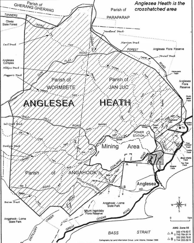
It is bounded by Forest Road to the east and Tanners Road to the north; the western boundary is a line between the end of Tanners and Batson Roads and the southern boundary is Mt Ingoldsby Road, Fraser Avenue, Camp Road and Betleigh Street to the Great Ocean Road
Of the Heath’s 7000 hectares, the types of EVC’s are interesting.
About 4000 hectares are healthy open woodland, mainly dominated by Eucalyptus obliqua.
1500 hectares are depleted tall, mixed lowland forest.
700 hectares are depleted swampy riparian woodland.
200 hectares are depleted sedgy wetland.
4 hectares are shallow, fresh water marsh.
The Anglesea Heath is part of, and similar to, the Eastern Otways in its ecology. Thus it is part of an incredibly important, biodiversity region of the world.